
Reading the landscape
Having described on the introductory page the regional and then local context in which the Barbaresco area is set, it is now time to narrow our scope and focus on the appellation itself..
Starting from the same panoramic image and putting less emphasis on the main geographical references outside the denomination, four points that previously seemed unimportant stand out. These points are actually very important, both because they will often serve as a reference when navigating through the many panoramic images on this site and because they will help you find your way around once you set foot on the territory.
- Barbaresco, because it identifies the point of the appellation closest to the Tanaro Valley.
- Neive, because it identifies the easternmost part of the denomination, bordering Monferrato and the province of Asti.
- Villa di Gresy, because it is located not far from the point where the municipalities of Treiso, Neive and Barbaresco touch each other, and because its position makes it visible from many corners of the denomination, even though it does not occupy the highest point.
- Treiso, whose importance will be more evident in the second panoramic image and the map published below.
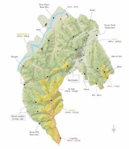
The second panoramic image gives due prominence to the hamlet of Cappelletto, located at the highest point of the denomination. From here, descending along the road in the centre of the image and gradually rotating the view 180° to the left, one arrives at Treiso, whose position appears truly strategic, given that right at that point the Cappelletto ridge divides into four secondary ridges descending in a northerly direction towards the Tanaro Valley: that of Rizzi and Nervo, that of Ausario, that of Marcarini, and finally that of Ferrere and San Stunet, each of which will be analysed in detail in the profile dedicated to the municipalities of Treiso and Alba.
Così come i crinali scendono da sud verso nord, lo stesso fanno anche le quote altimetriche che degradano dai 500 metri sul livello del mare di Cappelletto ai 150 metri della Valle del Tanaro. Stessa cosa vale per il crinale del Bricco di Neive, visibile in lontananza ruotando la seconda immagine verso sinistra, e le cui parti più alte arrivano a toccare i 450 metri sul livello del mare.
Just as the ridges descend from south to north, so do the elevation, which drops from 500 metres above sea level at Cappelletto to 150 metres in the Tanaro Valley. The same applies to the Bricco di Neive ridge, visible in the distance by turning the second image to the left, whose highest parts reach 450 metres above sea level.
Turning finally to the village of Treiso – as we will see more clearly on the page Landscape, Geology, Microclimate – it also marks the point at which these three factors change almost abruptly, in particular the landscape and climate.
That is why reading the landscape is an art worth learning.