A bit of geology
Much I have already written in the eponymous page that you will find in the Barolo section and even more in the volumes Barolo MGA Vol. 1 and Barbaresco MGA, to which I refer you.
Here, therefore, it will be sufficient to dwell on the highlights.
First, in the Barbaresco area, as well as in Barolo, soil and subsoil are of marine and sedimentary origin, which means that the subsoil, which originated when the entire area of Albese was covered by the sea, can be described as a series of layers overlapping one another and quite similar to what can be seen in the background image.
These layers, based on the time they originated and their stratigraphic characteristics, are then grouped and classified into what geologists call “formations“. The typical formations of the Barbaresco area and their characteristics are summarized in the table below.
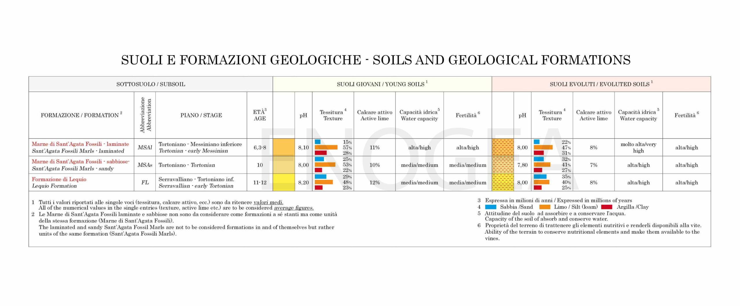
As you will notice by comparing it with the table published in the section dedicated to Barolo, the formations involved are far fewer in number, since they are limited only to the Sant’Agata Fossili Marls, declined in two different types (sandy and laminated), and the Lequio Formation, which here in Barbaresco is even further away than in Barolo from its more typical structure that can be observed in Alta Langa (i.e., the southernmost and highest area of the Langhe).
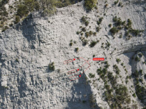
Specifically in the Barbaresco area the layers of Pietra di Langa, as can be seen in the image below, are scarce and are even less so as one moves from south to north in the direction of the Tanaro River valley. Although the prevailing element is always silt, slightly higher than in the Barolo area is instead the sand content, and this particular composition could explain, together with the microclimate, the generally more slender and fruity character compared to the Barolos of Serralunga d’Alba.
More generally, it should similarly come as no surprise that other data given in the geological table may differ from those reported in the table for the Barolo area.
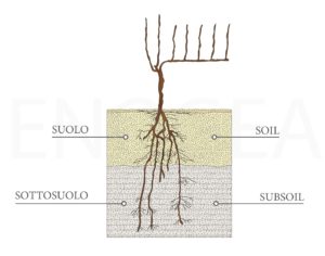
Having said that, possibly even more important is the distinction between SOIL and SUBSOIL.
As clarified in the figure below, by soil we mean the layer in which most of the vine roots develop, while subsoil or bedrock means the layer immediately below.
Soil, which usually originates from the subsoil, can then be classified into two categories: young soils and evoluted soils.
Young soils, which originate from a continuous erosive action of the subsoil by atmospheric forces and which, for this reason, maintain roughly the same characteristics as the initial formation; and evolved soils, which are typical of more gradual slopes that are less subject to erosion and therefore undergo a more severe chemical-physical alteration, of which the reddish coloration is only the most evident aspect. A typical example of young and evoluted evoluted soils can be seen in the third panoramic image published in the Landscape, Geology, Microclimate section.
From an oenological point of view, and in very general terms, young soils render wines of less color and fruit, but with more classic tannic structure, while evolved soils favor more intense and deep color, more explicit fruit and coarser tannic texture.
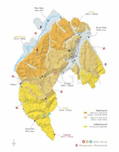
To sum up, below you will find the geo-viticultural map of the appellation, published in the Barbaresco MGA book and also available for purchase separately in printed form on the Enogea webstore.
Note. I have already written this elsewhere, but I will never tire of repeating it. What you will find written on this topic, as well as the geo-viticultural map, comes from the fundamental collaboration with agronomist Gian Piero Romana, the true catalyst of this project, and Edmondo Bonelli, an all-round geo-agronomist. I owe a great deal to them (repetita).